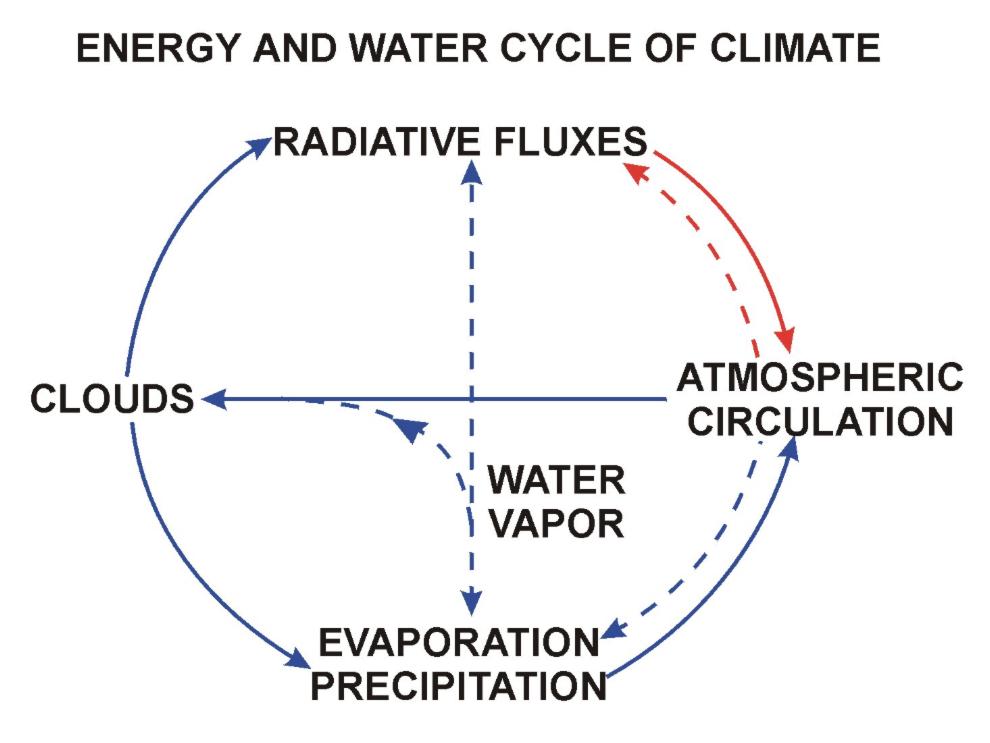
The Global Energy and Water Cycle of Earth's Climate
The schematic shows the relationships among the main components of the climate system (ocean and land implicit at surface) that compose the energy and water cycle. Spatially and temporally inhomogeneous solar radiation heats the surface (transferred energy producing varying temperature gradients in the atmosphere − red arrows − as well as in the ocean and on land). The blue arrows show subsequent reactions and interactions. The surface cools mainly by evaporating water rather than radiation because of the greenhouse effect. Atmospheric circulations produce clouds that produce precipitation to close the water cycle, but clouds also alter the radiative exchanges that drive the atmospheric and oceanic circulations.
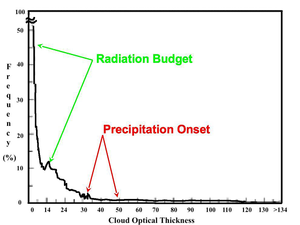
Cloud Optical Thickness
Clouds cover nearly 70% of the Earth but exhibit a large range of optical thicknesses, related to water mass. The distribution of the frequency of occurrence (y-axis) of cloud optical thicknesses (x-axis) shows that most clouds have low values, providing most of the coverage and most of the influence on the radiation budget. Only the much less frequent clouds with large optical thicknesses, about 10% of the total, produce precipitation.
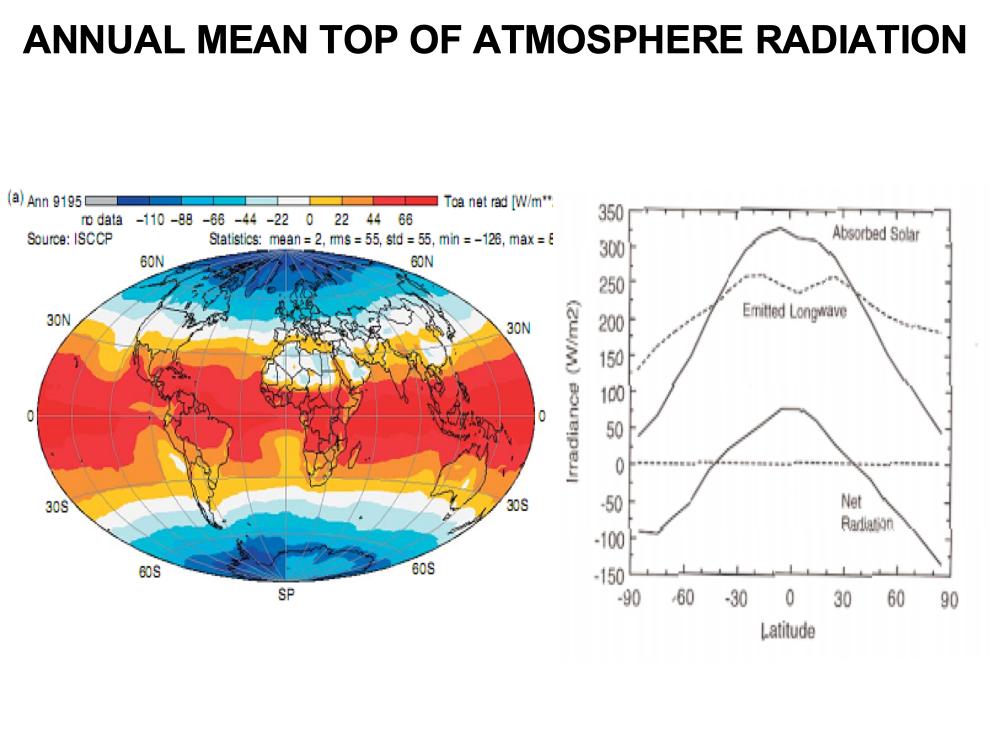
Annual Mean TOA Radiation
The latitudinal distribution of the annual mean radiation at the top of the atmosphere (right panel in W/m2) shows solar heating (absorbed solar) decreasing from the equator to the poles, balanced in a globally averaged sense by thermal radiation (emitted longwave). The difference, the total net radiation, exhibits heating (positive values) at lower latitudes (red to orange color in map) and cooling (negative values) at the poles (blue colors in map). The geographic distribution (left panel) of the total net radiation (absorbed solar minus emitted longwave) drives atmospheric and oceanic circulations that transport some of the energy towards the poles and reduce the thermal cooling at the equator and increase it at the poles.
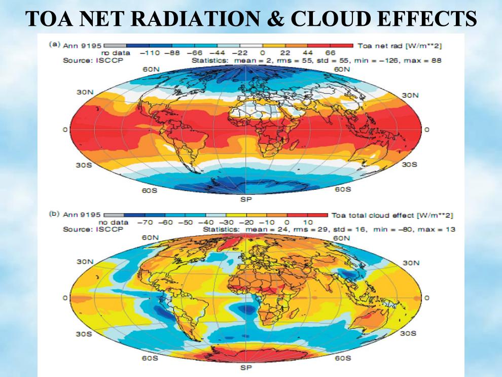
TOA Net Radiation & Cloud Effects
The upper panel shows (in W/m2) the total net radiation (absorbed solar minus emitted thermal longwave) at the top of atmosphere (TOA). The cloud effect on the total net radiation (lower panel) reduces the radiative heating, (orange, yellow colors), most strongly at midlatitudes (blue colors), but decreases the radiative cooling at the poles (orange, red colors). The total net cloud effect is generally negative because clouds reflect more solar radiation than the clear atmosphere, but reduce thermal emission less. However, in the polar regions the cloud reduction of thermal emission is larger than the solar reduction over bright snow-ice surfaces.
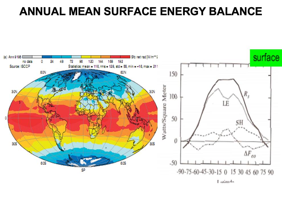
Annual Mean Surface Energy Balance
Most of the solar radiation at the top of the atmosphere penetrates the relatively transparent atmosphere, blocked only by clouds, and heats the surface (RS in W/m2, zonal average to the right). Because of the opacity of the atmosphere to thermal radiation due to water vapor is large (the greenhouse effect), the lower atmosphere is at nearly the same temperature as the surface. As a result both the net thermal cooling of the surface (∆F0) and the direct transfer of heat (sensible heat, SH) are small. The geographic distribution of the total radiation (absorbed solar minus emitted thermal) is shown on the left in W/m2. Thus, the surface cools mainly by evaporation of water (LE).
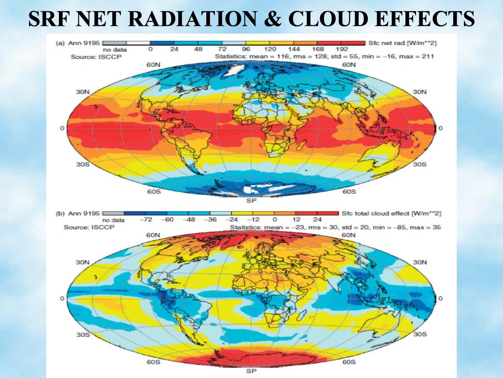
SRF Net Radiation & Cloud Effects
The net radiative heating of the surface (SRF) is shown in the upper panel (in W/m2). Clouds (lower panel) reduce the solar heating at most latitudes (yellow, blue colors) but inhibit the thermal radiative cooling of polar surfaces (an effective heating, red colors). These effects reduce the equator-to-pole gradient in radiative heating of the surface that weakens the radiative forcing of the oceanic circulation.
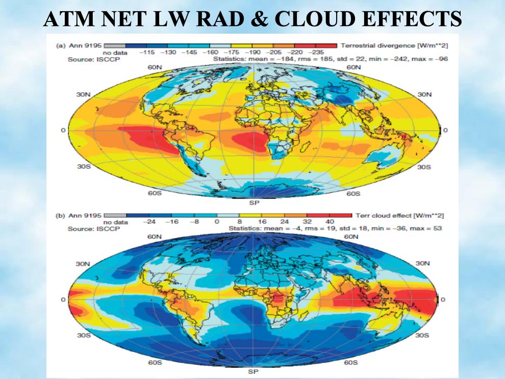
ATM Net LW Rad & Cloud Effects
The thermal radiation cooling (net longwave, LW) at the top of the atmosphere comes mostly from the atmosphere (ATM, all colors in the upper panel in W/m2), which blocks most of the thermal radiation from the surface. Thus, the radiation budget at the top of the atmosphere is formed mostly from solar heating of the surface and thermal emission from the atmosphere. The transfer of surface energy to the atmosphere is accomplished by evaporative cooling of the surface and heating of the atmosphere by precipitation (the water cycle). The cloud radiative effect on the atmospheric net radiation (lower panel) is to reduce the thermal emission at low latitudes, enhancing the net radiative heating (yellow to red colors), but to increase the thermal emission at higher latitudes, enhancing the cooling (blue colors). These effects increase the equator-to-pole gradient of radiative cooling that strengthens the radiative forcing for the atmospheric circulation.
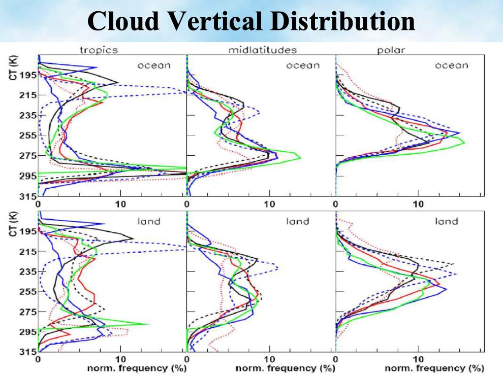
Cloud Vertical Distribution
Clouds tend to occur most frequently at two levels in the tropics and midlatitudes, near the tropopause and surface, but only in a single layer broad level in the polar regions. The different color lines show the distribution of the frequency of occurrence of cloud top temperatures (CT in Kelvins, related to height) from different satellite data products. The solid black lines are direct results from combined satellite lidar (CALIPSO) and radar (CloudSat) measurements.
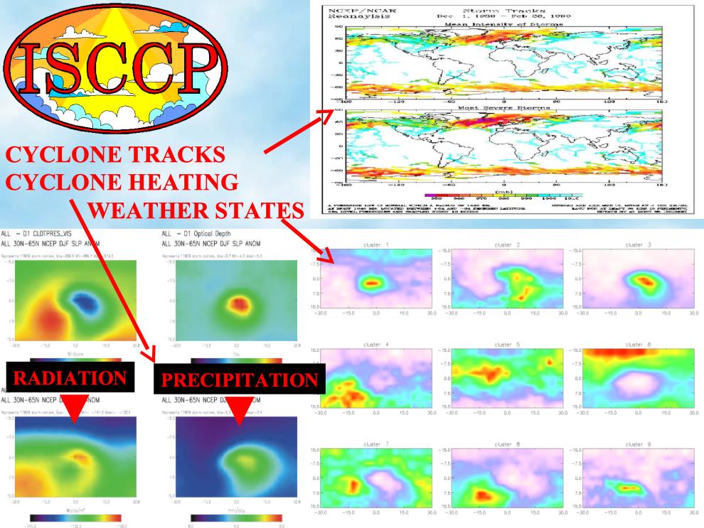
Midlatitude Storms
Midlatitude storms (disturbances with stronger turbulent winds and precipitation) move in west-to-east tracks (the upper right two panels show the frequency of occurrence from low in blue through green and yellow to high in red colors). These storms exhibit cyclonic rotation on relatively large spatial scales (of order 1000 km). The distribution within these storms of cloud top pressures (lower left above "radiation" label) varies from high pressure of low clouds in red on the upstream and equatorward side to low pressure of high clouds in blue at the center and downstream and equatorward side. The distribution of cloud optical thicknesses (lower left above "precipitation" label) varies from low values in blue around the periphery to high values in red in near the center). The thicker and higher-topped clouds in these systems exhibit smaller thermal radiation and larger precipitation (lower left) that heats the atmosphere. Distinctive assortments of cloud properties, called weather states, appear in characteristic locations within the storms. These are illustrated in the lower right set of nine panels (increasing frequency from low as pink through blue to high as red): the thickest and highest clouds that produce precipitation are in the first three states with the second one following the "comma-shape" of the cold front. The middle panel of the nine is a state with predominantly middle-level clouds that appears upstream of the cyclone center behind the cold front.
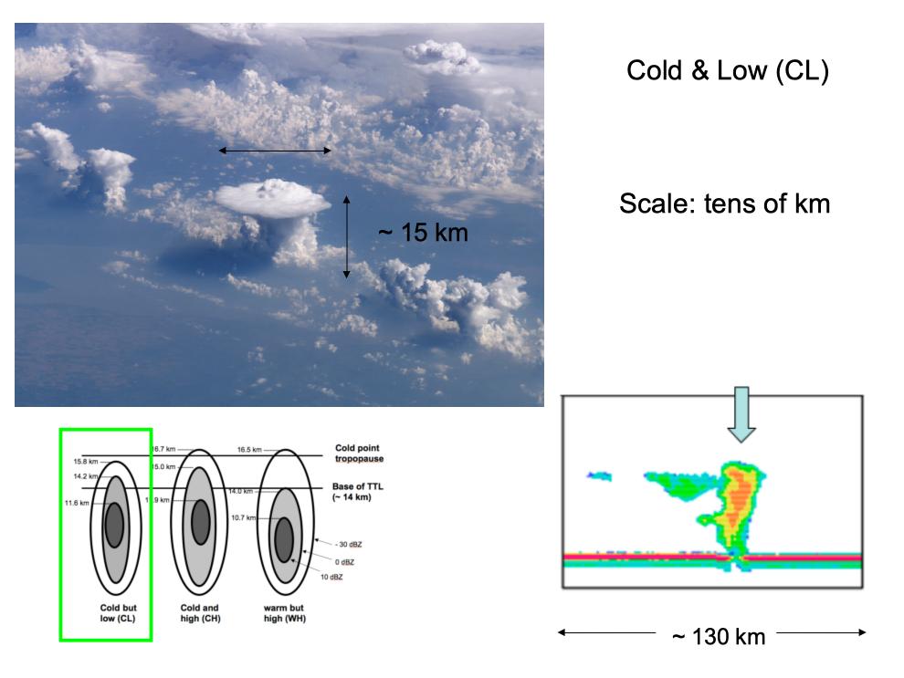
Tropical Convection - Small Convection
In the tropics, the buoyancy of near-surface air caused by heating from the surface leads to vertical motions that produce clouds and precipitation (called convection). The more numerous, smaller single plumes are the classical form on a convective storm (picture). An example satellite radar view is shown at lower right (intensity of radar return from low in blue to high in red indicating water mass). The schematic at lower left shows three different vertical distributions of three levels of radar return relative to the tropical tropopause (TTL is tropical tropopause layer of nearly constant temperature with height up to the cold-point height). Because of windspeed increases with height, the upper ice portions of these cloud systems are blown out to form a thin layer of cirrus clouds that do not precipitate; the radar does not detect most of this type of cloud. The horizontal and vertical dimensions of these storms are about 10-20 km.
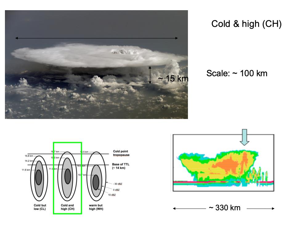
Tropical Convection - Large Convection
Much rarer and very large convective storms form with larger precipitating towers (plumes) and a much more extensive and thicker cloud layer that also produce significant precipitation in addition to that from the convective plume (picture). An example satellite radar view is shown at lower right (intensity or radar return from low in blue to high in red). The schematic at lower left shows three different vertical distributions of three levels of radar return relative to tropical tropopause (TTL is tropical tropopause layer of nearly constant temperature with height up to the cold-point height). These mesoscale systems are about ten times larger in horizontal dimension than the isolated plume storms. In midlatitudes a similar mesoscale system can acquire rotation from the horizontal wind gradient and produce large amounts of hail and tornadoes.
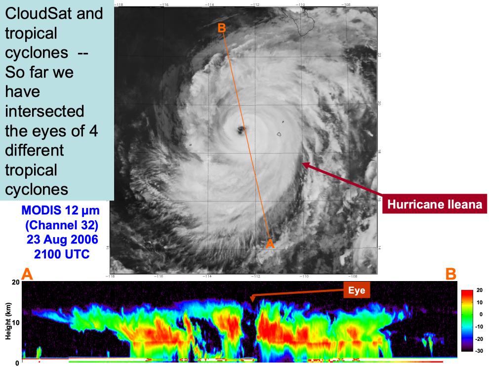
Tropical Convection - Hurricanes, Typhoons, Cyclones
An even rarer type of tropical storm, called by different names in different ocean basins (hurricane in the Atlantic, typhoon in the Pacific, cyclone in the Indian), is even larger than the mesocale systems. They have acquired significant rotation (picture) and produce even stronger winds and precipitation in multiple bands of strong convective motion (satellite radar below, intensity of radar return from low in blue to high in red).
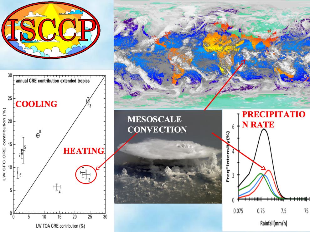
Tropical Convection - Mesoscale
Although rare, the mesoscale (and hurricane) storms produce the majority of the tropical precipitation and also produce the largest precipitation rates (red curve at lower right). Single plume convection produces smaller precipitation rates (blue curve at lower right) and other low-level clouds produce very light precipitation (green curve at lower right, note log scale on x-axis). The clouds in mesoscale convective weather states (labeled 1 and 2, in red circle at lower left) also produce radiative heating of the atmosphere (shown is the longwave cloud effect at the surface on the y-axis plotted against the longwave cloud effect at top-of-atmosphere on the x-axis for different weather states). The single plume weather states do not produce radiative heating of the atmosphere (labeled 3 in lower left). Weather state 4 at lower left is composed of extensive cirrus clouds that also cause upper atmospheric radiative heating.
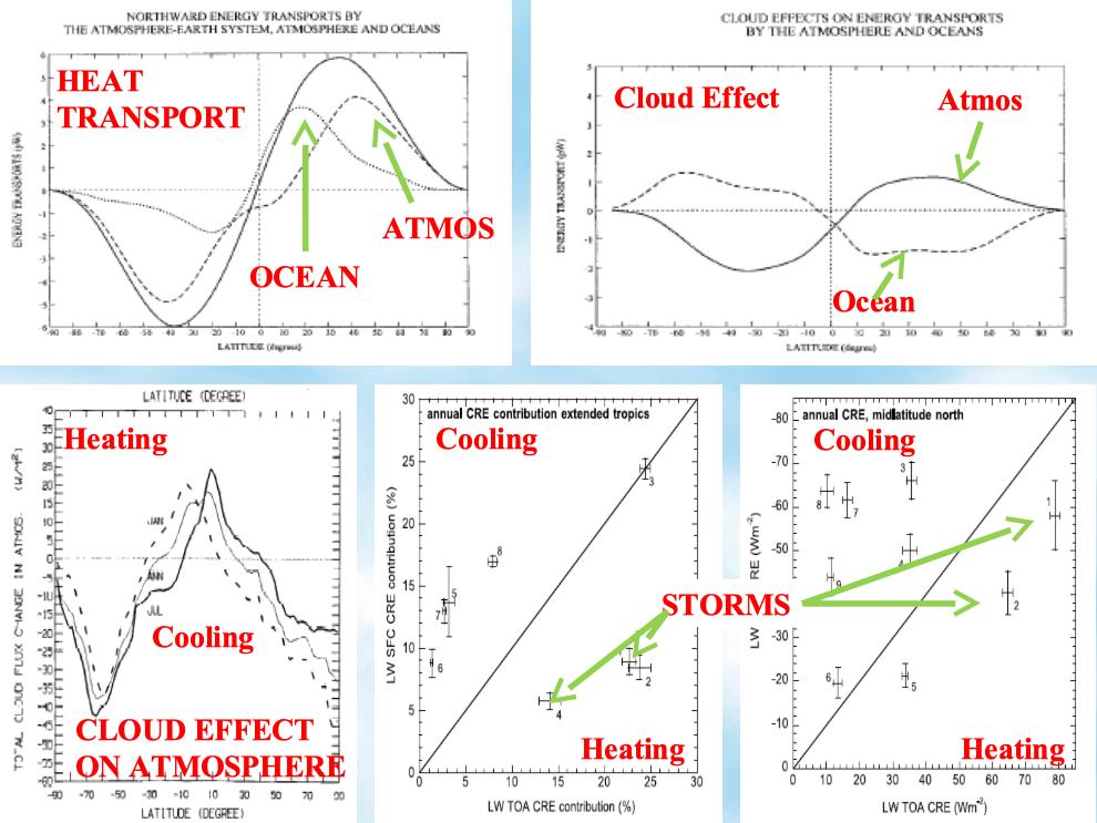
The Role of Clouds in Weather and Climate
The latitude distribution of the total energy transport (in petaWatts) that balances the top-of-atmosphere net radiation is shown as the solid curve in the upper left panel, separated into the contributions of the ocean and atmosphere. The net cloud radiative effect on the atmosphere (in W/m2) is shown in the lower left panel (annual mean as solid line): heating (positive values) at lower latitudes and cooling (negative values) at higher latitudes. The consequence of the cloud radiative effect, shown in the upper right, is that they act to enhance the atmospheric transport but to depress the oceanic transport (in petaWatts). The cloud radiative effects also enhance the strength of weather systems, especially precipitating storms (lower middle and right panels, which show the longwave cloud effect at the surface on the y-axis plotted against the longwave cloud effect at top-of-atmosphere on the x-axis for different weather states). In summary, cloud radiative effects act to increase the large-scale general atmospheric circulation but also, together with precipitation, they increase storm heating of the atmosphere. How these effects will change in a warming climate is still being investigated.